 No.73
No.73
夏の暑さを避ける知恵を研究
Researching the Wisdom on Avoiding Summer Heat
都市環境を改善するため、建築の専門家の視点を生かす
市街地の熱中症危険度マップを作成
Utilizing the perspective of an architecture expert to improve the urban environment
Mapping the level of heatstroke hazard in a city
環境都市工学部
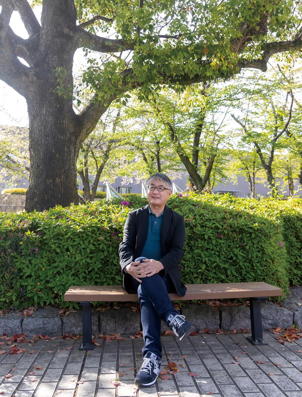
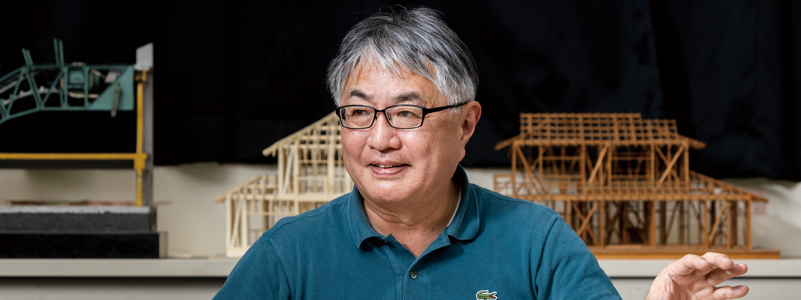
宮﨑 ひろ志 専任講師
Faculty of Environmental and Urban Engineering
Lecturer Hiroshi Miyazaki
地球温暖化などの影響で、日本の夏の平均気温は上昇を続けている。市街地を歩くだけで熱中症の危険にさらされ、「災害級の暑さ」という言葉が日常的に使われるようになった。1級建築士でもある環境都市工学部の宮﨑ひろ志専任講師は熱中症の危険度マップを作成し、安全な場所作りに生かすよう求めている。
The average summer temperature in Japan continues to rise due to factors such as the effects of global warming. Just walking around a town can put people at risk of heatstroke, and the term "disaster-grade heat" is now in common use. Hiroshi Miyazaki is a lecturer in the Faculty of Environmental and Urban Engineering and also a qualified First-Class Architect. He has created a hazard map for heatstroke and is urging people to use it to build urban spaces that are safe.
公務員として、大学の設計に携わる
以前は、兵庫県庁に勤めていたそうですね。どのような業務に関わっていたのか教えてください。
設計に携われるというので、1978年に神戸大学工学部を卒業した後、建築職で兵庫県庁に入庁しました。最初は建築基準法や都市計画法などに基づく許認可事務を担当し、その後は7年間にわたり設計の業務を行いました。
携わった設計は大学関連施設が多く、神戸商科大学(現・兵庫県立大学)を新キャンパスに移転する際の設計や、姫路工業大学(同)理学部キャンパスを兵庫県上郡町に建設する仕事などに関わりました。
県庁を退職した後は、兵庫県立自然系博物館(現・兵庫県立人と自然の博物館)の設立準備室や姫路工業大学自然・環境科学研究所に勤務し、その頃から都市環境をテーマに研究しました。桜の開花は都市部が早いということを県内の小学校と連携して調べたこともあります。関西大学には2007年に着任しました。
Involvement in university design as a public servant
I understand you used to work for the Hyogo Prefectural Government. What kind of work did you do?
I heard that I could be involved in design, so after graduating from the Faculty of Engineering at Kobe University in 1978, I joined the Hyogo Prefectural Government as an architect. At first, I was in charge of licensing work based on the Building Standards Act and the City Planning Act. After that, I did design work for seven years.
A lot of the design I was involved in was for university-related facilities, such as the design work when Kobe University of Commerce (which is now the University of Hyogo) relocated to a new campus. I was also involved in the work to construct the Faculty of Science campus of the Himeji Institute of Technology (which is also now the University of Hyogo), in Kamigori Town in Hyogo Prefecture.
After I left the prefectural government, I worked in the office preparing for the establishment of a Hyogo Prefectural museum of natural history (which is currently the Museum of Nature and Human Activities, Hyogo). I also worked at Institute of Natural and Environmental Sciences of the Himeji Institute of Technology, which is where I began research on the theme of urban environments. I once conducted an investigation with elementary schools in the prefecture regarding how cherry blossoms bloom earlier in urban areas. I joined Kansai University in 2007.
都市環境計画が専門
現在、どのような研究や教育をされていますか。
専門は都市環境計画です。もともと都市計画は、19世紀末から20世紀初頭にかけて、ロンドンやニューヨークなどの大都市が公害などにより生活環境が悪化したことを背景に誕生したものです。当初は環境を改善することが都市計画の目的だったのですが、都市が高度化する中、建物や道路などの都市構造物の適正配置などに関心が向いています。
私自身は、今の時代の都市計画は、当初の目的に立ち返るべきだと思っています。現在、日本は低炭素社会実現のため、「2030年度に、温室効果ガスを2013年度から46%削減する」「2050年までに温室効果ガスの排出を全体としてゼロにする」ことを目指すと世界に宣言しています。ということは、2020年代に大学を卒業した学生が30歳、そして50歳くらいになる頃には達成できていなければなりません。働き盛りの一番大切な時期を使って社会を変えていく必要があります。そういう視点で住宅の建築やまちづくりを研究し、学生を指導しています。
心強いことに、私のゼミの卒業生には、大手企業で駅前開発などのまちづくりに携わっている人が多くいますので、今後、環境の時代のまちづくりを実践してくれたらいいなと思っています。
Specialization in urban environmental planning
What kind of research and education are you doing now?
I specialize in urban environmental planning. City planning was originally conceived from around the end of the 19th century to early in the 20th century, when problems such as pollution were causing deteriorating living conditions in large cities such as London and New York. The original purpose of city planning was to improve the environment. However, as cities become more sophisticated, attention began to turn to matters such as the best arrangement of the buildings, roads and other urban structures.
My personal opinion is that city planning should now return to its original purpose. Japan has declared to the world that it will work towards the realization of a low-carbon society by aiming to reduce its greenhouse gas emissions by 46% from fiscal 2013 levels by fiscal 2030, and to net zero by 2050. This means that for students graduating from university in the 2020s, these targets will need to have been met when those graduates are around 30 years old and around 50 years old. It will be necessary for them to use the most important period of their working lives to change society. That is the perspective I take when I study residential architecture and community planning, and when I instruct the students.
Encouragingly, many of the graduates of my seminar are now working at major companies and are involved in city development such as the redevelopment of areas in front of railway stations. My hope is that they will practice city development that is appropriate for this era of the environment.
暑い沖縄で「中村家住宅」が快適な理由
研究内容を具体的に紹介してください。
2008年から2019年まで、沖縄にある国指定重要文化財「中村家住宅」の屋根瓦を研究しました。18世紀中頃に建てられたと伝えられている住宅です。大阪や九州の屋根瓦は日差しを浴びるととても熱くなるのですが、中村家住宅の場合はひんやりして冷たいのが特徴です。
理由は素材にありました。中村家住宅の屋根瓦は現代の瓦と違って素焼きです。そのため雨水を吸い込み、日が当たると水分が蒸発する際に、気化熱により熱が奪われるという仕組みでした。
さらに屋根を調べると、竹を敷いた上に土を載せ、その上に屋根瓦を並べる構造で、全体的に隙間だらけだと分かりました。実際に、実験で無害な煙を屋根裏に発生させ、煙が外に抜けて出ていく様子を確認しました。中村家住宅の屋根は、雨水は通さないけれど室内を蒸し暑くする水蒸気は逃がし、室内を快適にしています。
昔の人の知恵はすごかったんですね。
そう思います。現代の建築は、素焼きのような多孔質の建材を嫌います。水を吸うとこけが生えたり、凍ると割れてしまうためです。しかし、昔の人はこれほどまでに素材を生かしていたのだと知り、驚きました。
戦後、JIS(日本工業規格)ができてから、瓦は水を吸わず、重ねたときに隙間ができないことを目指すようになりました。私たちは新しくて良いものを作っていたつもりだったのですが、暑熱をしのぐ先人の知恵を失い、エネルギーを使う空調に頼るようになっていったのだと思います。
Why the "Nakamura House" is comfortable despite the heat in Okinawa
Please introduce some of your specific research.
From 2008 to 2019, I studied the roof tiles of the "Nakamura House," which is a nationally designated Important Cultural Property in Okinawa. It is said that the house was built in the middle of the 18th century. Roof tiles in Osaka and Kyushu become very hot when the sun shines on them. However, in the case of the Nakamura House, they remain cool.
The reason for this is the material they are made from. Unlike modern tiles, the roof tiles on the Nakamura House are unglazed. This means that they absorb rainwater. The mechanism of the cooling is that the moisture then evaporates when the sun shines on the tiles, and heat is taken away by the latent heat of vaporization.
Further inspection of the roof revealed that it has a structure that is full of gaps. Bamboo had been laid first, soil was placed on top of the bamboo, and then the roof tiles were arranged on top of the soil. In an experiment, I actually generated a harmless smoke in the attic area and confirmed how it moved to the outside. The roof of the Nakamura House does not allow rainwater to pass through it, but it does allow water vapor to escape. This prevents the interior becoming hot and humid, so this makes the interior comfortable.
The wisdom of the people of the past was amazing.
I agree. In modern architecture, porous building materials like unglazed pottery are disliked. This is because if water is absorbed, then moss may grow on the material, and also the material may split when it freezes. However, I learned that people in the past made such great use of these materials. This was a surprise.
In the postwar period, after the establishment of the Japanese Industrial Standards (JIS), the goals for roof tiles became to prevent them from absorbing water and to ensure that no gaps are created when they are arranged. We thought we were building something new and better, but I think we had squandered the wisdom of our predecessors on how to handle the heat and we just began to rely on air conditioning that required energy use.
●沖縄「中村家住宅」の屋根瓦に学ぶ暑熱対策
Study of Cooling Methods from Roof Tiles of Nakamura House, Okinawa
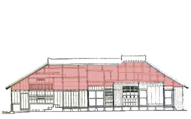
大きな屋根で確保した大きな小屋裏空間
Attic spaces secured by a large roof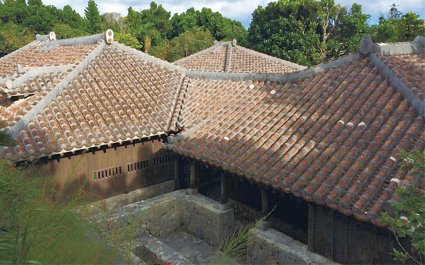
素焼きの琉球赤瓦で覆われた屋根を有する
「中村家住宅」
Nakamura House roofed with unglazed Ryukyu red tiles
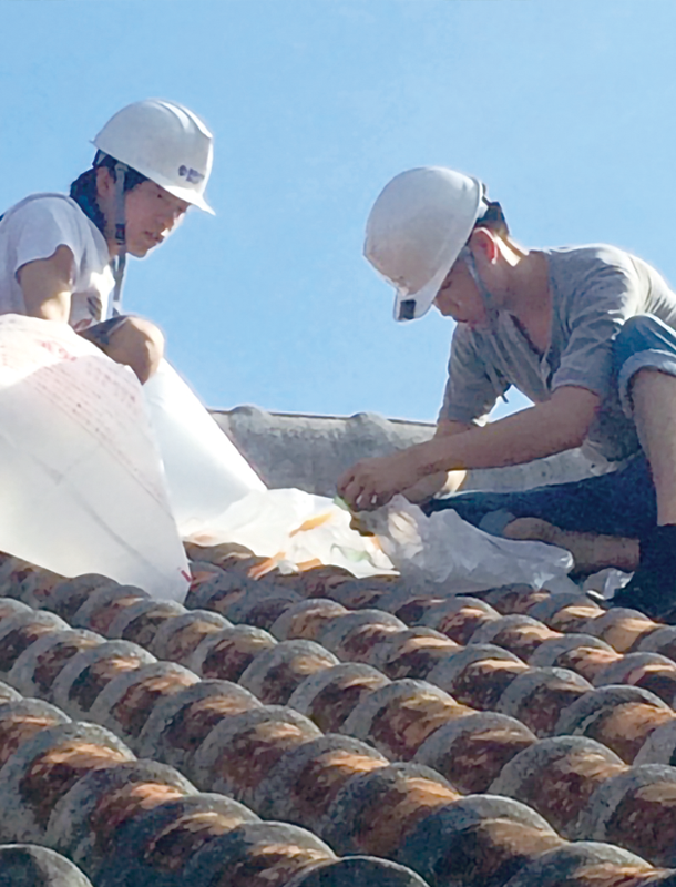
屋根瓦の調査を行う研究室の学生
Research laboratory students investigating roof tiles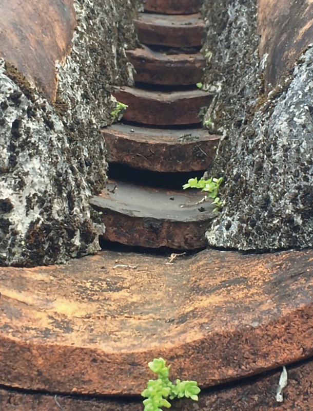
瓦には換気のための隙間がある
Gaps between tiles allow for ventilation
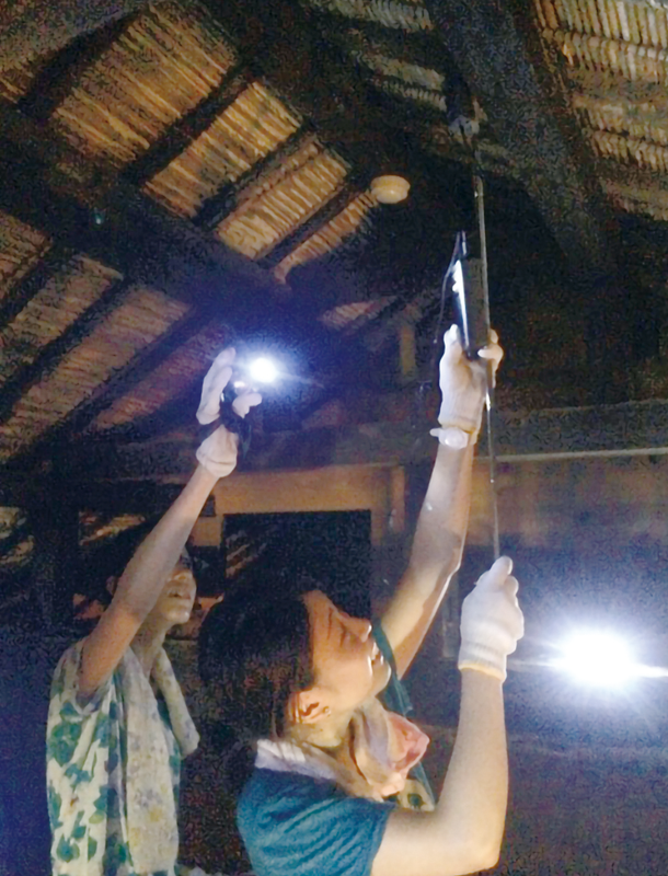
土と竹で組まれた小屋裏空間。
雨水は通さず、通気を保つ
Attic area created by the soil and the bamboo, which does not allow water to pass through but keeps the ventilation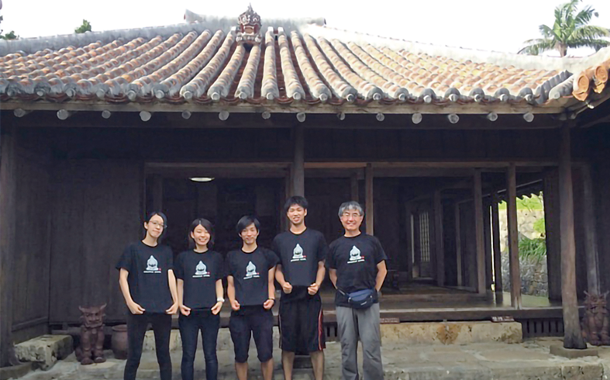
共に調査を行った学生たちと
With the students who investigated together
熱中症を防ぐまちづくりのために
熱中症対策も研究していると伺いました。
日本では近年、毎年のように1,000人以上が熱中症で亡くなっています。今後さらに温暖化が進むと、被害は深刻になるでしょう。私は建築分野から、熱中症を防ぐまちづくりをすることで温暖化対策に貢献できると考えています。
市街地の温度を下げるためには、日よけを作る、木を植える、ミストを散布する、道路の舗装を変える、などさまざまな対策が考えられます。ただ、全ての場所で対策を取ることは現実的ではありません。一番危険な場所から着手するべきなのですが、その場合に「どこから手をつけていいか分からない」という問題が生じます。そこで私たちは、地方自治体に活用してもらうことを想定し、市街地の各地点の暑さと人の流れをシミュレーションしながら、熱中症の危険度が一目で分かる地図を作成することにしました。
対象地域は、兵庫県神戸市のJR三ノ宮駅南側の中心市街地を選びました。兵庫県にはLiDAR(ライダー)というセンサーを航空機に積んで得られた樹木1本1本の高さも分かるデータがあり、このデータを活用すればより正確なシミュレーションが可能になると考えました。
樹木の高さのデータはなぜ必要なのですか。
熱中症の危険度は気温だけでは計れません。例えば、湿度が高いと汗が蒸発せず、暑く感じます。また、照り返しも大きな要素です。地面や壁面が太陽光で熱せられると、表面から赤外線が出て体に当たり、暑さを感じるのです。市街地の暑さをシミュレーションするには、この照り返しの強さも計算に入れなくてはならず、建物のデータに加えて緑陰を作ってくれる樹木のデータも必要です。
照り返しの強さは、人工の建物と植物で全く異なります。植物は光合成をする時に水を蒸散するため、暑さを緩和してくれます。建物の影と比べて木陰が涼しいのはこのこともあるからです。
気温や湿度、風速、日射、建物からの赤外線量などのデータを使って暑さをシミュレーションしました。さらに携帯電話の位置情報から得られた人流データも加味して地図に表し、暑い時間が長く続き、多くの人が集まる熱中症対策を急いだ方がよい場所が分かるようにしました。
City planning to prevent heatstroke
I heard that you are also researching measures against heatstroke.
Recently in Japan, it seems that almost every year more than 1,000 people die of heatstroke. As global warming progresses, this will no doubt get even worse. As someone in the field of architecture, I believe that I can contribute to the measures to deal with global warming through city planning that prevents heatstroke.
There are many different ways to reduce the temperature in a city area. For example, this includes by creating shade, planting trees, spraying mist, and changing the materials of the pavements. However, it is not realistic to try to implement such measures everywhere. We need to start from the places that are the most dangerous. However, this leads to the question of where we should start. This is why we decided to create a map that shows the level of risk of heatstroke at a glance, with the assumption that it could be put to use by local governments. The map creation is performed by simulating the heat and the flow of people at each point in a city area.
As the target area, we selected the central urban area to the south of the JR Sannomiya Station in Kobe City, Hyogo Prefecture. Hyogo Prefecture has data indicating the heights of each individual tree, which were obtained by mounting a sensor called a LiDAR on an aircraft. We thought that using that data would enable us to perform more accurate simulations.
Why do you need to know the data on tree heights?
The risk of heatstroke is not just determined by the air temperature. For example, it feels hotter if there is high humidity, because sweat does not evaporate. The reflected heat is also a big factor. When the ground or a wall is heated by sunlight, infrared rays are emitted from its surface. We feel the heat when those rays hit our body. In order to simulate the heat in an urban area, it is necessary to also include the intensity of this reflected heat in the calculations. Therefore, in addition to the data on the buildings, it is also necessary to have the data on the trees, which produce shade.
The intensity of the reflected heat is completely different between man-made buildings and plants. Plants evaporate water when they photosynthesize, which helps reduce heat. This is one reason why it is cooler in the shade from trees than in the shadow of a building.
We simulated the heat using data such as temperature, humidity, wind speed, solar radiation, and the amount of infrared radiation from buildings. We also added data on the flow of people, which we obtained from mobile phone location data. We expressed all of this in a map and made it possible to see the points where measures against heatstroke should be a priority. This was the places where it was hot for a long time and also there were a lot of people.
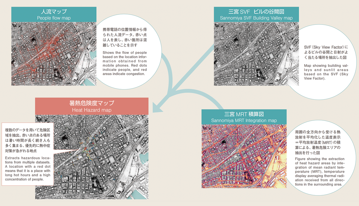
神戸・三宮を対象にした熱中症危険度マップの抽出
Heat stroke risk maps for Sannomiya, Kobe
景観より安全第一の時代に
熱中症の危険度マップの重要性はどこにあるのでしょうか。
専門用語を使うと、「熱中症対策は輻射(ふくしゃ)環境を良くすればいい」というメッセージになっています。輻射は照り返しのことです。これからは、例えば樹木1本を選ぶ場合でも、景観だけではなく安全を第一に考えて決める時代になると期待しています。私たちの研究が安全なまちづくりに役立てばうれしいですね。
An age where safety is more important than the landscape
What do you think makes the heatstroke map important?
To use technical terminology, it is because it communicates the message that if we want to take measures against heatstroke, we need to improve the radiation environment. This radiation is the reflected heat. My hope is that from now on, even if we are only talking about selecting a single tree, any landscape choices will be made with consideration of safety as a priority over the appearance. It would be great if our research could play a role in safe city planning.