No.17
21 July 2021
Learning from the Past—Predicting Tsunamis Better Through New Technology
Tomoyuki Takahashi
Professor, Faculty of Societal Safety Sciences
Professor Takahashi's Interview
Professor Tomoyuki Takahashi from Kansai University, Japan, recalls the time the Great East Japan Earthquake Tsunami hit the Tohoku region in 2011. It was his first year at the university and he remembers rushing to the site to conduct a survey. However, when he reached, all he could do was walk around in a daze while witnessing the destruction the tsunami had left in its wake.
Takahashi recalls, "The cities I lived in as a student at Tohoku University, the guest house where we shared drinks, and the home where I tutored— to see them all ravaged by the disaster came as a real shock. What was once my everyday life no longer existed."
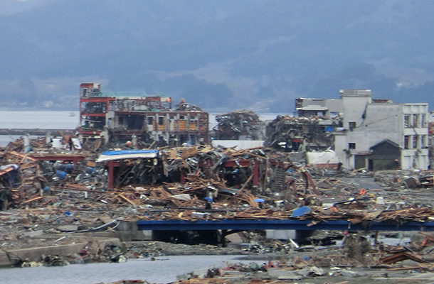
The Great East Japan Earthquake Tsunami hit the Tohoku region in 2011 and had devastating consequences
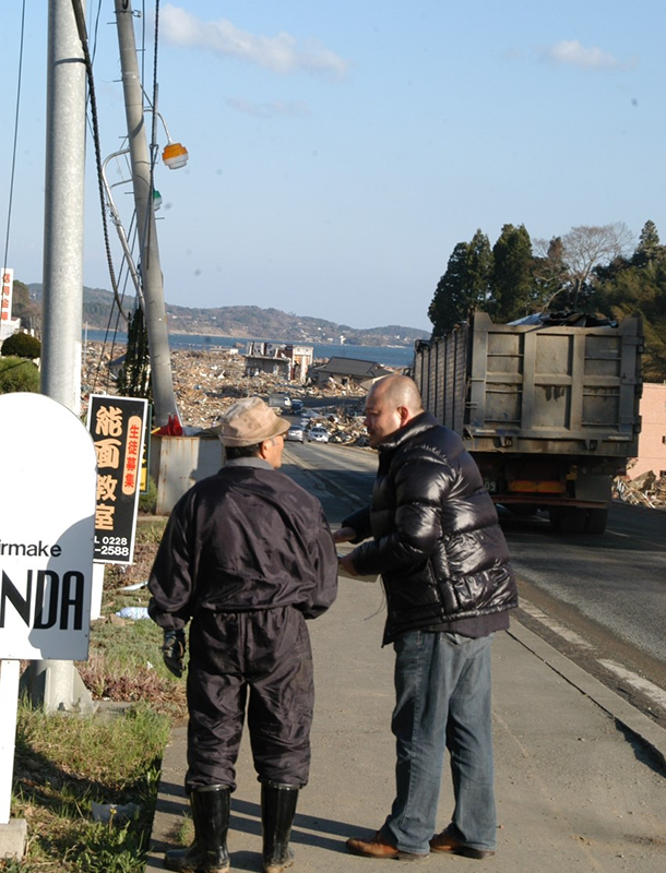
Prof. Takahashi conducted a detailed survey on the Tohoku tsunami
The experience changed Takahashi's outlook forever. Until then, he had conducting research disaster mitigation by conducting surveys and collecting data. But following the 2011 Earthquake Tsunami, Takahashi took it upon himself to communicate his research findings to the general public and help them prepare for future disasters.
He explains, "I felt responsible for making them aware of an impending crisis because, otherwise, all my research and papers would mean little more than self-satisfaction."
Armed with the motivation to create an impact, Takahashi and colleagues then extensively researched the 2011 Earthquake Tsunami, carrying out a nation-wide survey that produced the largest tsunami dataset in the world, to understand what had made the disaster so devastating. Their findings were published in Geophysical Research Letters and Coastal Engineering Journal, which are among the highest cited journals (top 1%) in the field of disaster prevention!
The revelations were striking. The Great Tohoku Earthquake Tsunami, it appeared, was the kind of mega-tsunami that occurs once every thousand to several thousand years! Unfortunately, all data on past tsunamis only dated back to several hundred years and, consequently, failed to estimate the true scale of the tsunami, leading to great damage and loss of lives.
"This was an important clue for future tsunami disaster preventions," says Takahashi. "Based on this, we're assuming the largest class of earthquakes and tsunamis for the upcoming Nankai Trough Earthquake—something we may not have experienced in the last several hundred years but can nonetheless occur."
Usually, the Japan Meteorological Agency (JMA) issues a tsunami warning within minutes after an earthquake occurs, the quickest response in the world, and the 2011 earthquake was no exception. However, the warning had underestimated the tsunami size and, therefore, left people underprepared. While the JMA realized its mistake soon and accordingly issued a revised warning, a power outage had occurred in the meantime. Takahashi believes the ill-timed power cut likely prevented the second warning from reaching the city's residents.
"Through this, we learned the importance of the first report of disaster management," Takahashi says.
To make for more accurate tsunami warnings, Takahashi believes one needs to observe the waves themselves, as one can only go so far in predicting what will happen without an actual observation.
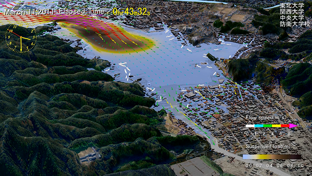
To that end, he is currently conducting research on tsunami observation and prediction using ocean radars that rely on measuring the frequency of reflected radio waves from oceans to estimate the speed of the water surface. Compared to ocean buoys, which collects data at a particular point, ocean radars can observe an entire area and, correspondingly, collect more data. "This allows us to know exactly when a tsunami has occurred, allowing for a quicker response and reduced secondary damage," explains Takahashi.
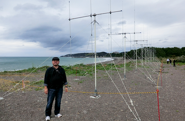
An ocean radar tsunami observation system
In addition, Takahashi has developed advanced damage prediction models that attempt to realistically simulate the mechanism underlying a water-related disaster. Before the 2011 earthquake, Takahashi would base his predictions on simulations of water movement alone. But the survey changed his perspective.
"In an actual tsunami, the movement of water leads the sand to move along the seabed, while changing the terrain. This tsunami is more destructive than that with water alone, carrying with it ships and buildings that can turn into deadly weapons that claim the lives of people and increase the severity of damage," explains Takahashi. "A realistic prediction model, therefore, needs to integrate such various factors."
This knowledge of tsunamis carrying sand, also called "black tsunamis" prompted the development of a realistic prediction model, which was Prof. Takahashi's biggest research achievement with regard to the 2011 Earthquake Tsunami survey. This model was developed in collaboration with a research team from Kansai University, Tohoku University, Chuo University, and National Defense Academy of Japan.
A realistic "Black Tsunami" prediction model
Moreover, Takahashi explained that the wreckage caused by black tsunamis is left behind in the city even after the tsunami has subsided, hindering evacuation and rescue efforts. It is, therefore, essential for the government and citizens to know in advance what to expect in the event of a disaster.
"If we know how much debris can accumulate at a particular location due to the disaster, it is easier for the government to take action in advance, such as prioritizing debris collection and diverting evacuation routes," Takahashi says.
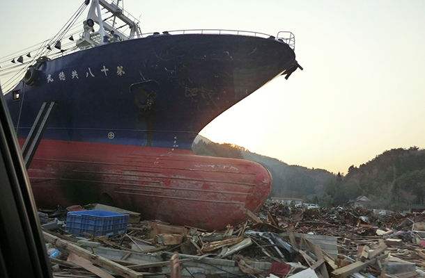
The tsunami caused massive destruction, leaving behind large amounts of debris
Not just this, in addition to simulating the disaster, Takahashi has also taken into account human behavior during such crises.
"At the time of the Great East Japan Earthquake, human behavior was very complicated," observes Takahashi. "Although evacuation on foot was recommended, many people used cars to escape. We must, therefore, consider evacuation modes other than walking to firmly predict human behavior during a disaster, especially if it occurs in urban areas."
Accordingly, Takahashi has developed a model that simulates walking and vehicle motion simultaneously, allowing him to predict the kind of complications that can arise and how to avoid them.
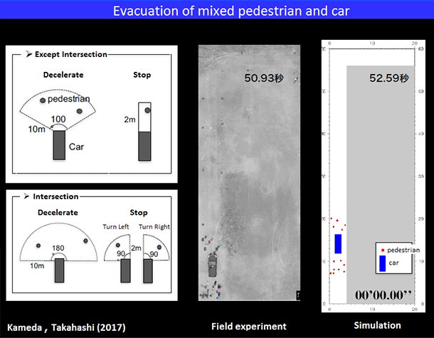
A model simulating the movement of pedestrians and cars during evacuation
All this is, however, only part of the story. True to his resolution, Takahashi has developed tools to educate the masses in preparation of the imminent Nankai Trough Earthquake. These include an augmented reality (AR) software that simulates a tsunami on Port Island in the city of Kobe and an iPhone application based on the tsunami hazard map of Sakai, a city in Osaka.
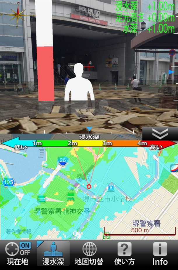
An AR-based application developed by Prof. Takahashi can provide information about tsunami and evacuation
"The tool essentially converts numerical data into images to help people intuitively understand the risks at their current location, home, school, or workplace, and what actions they should take in the event of a disaster," explains Takahashi. He believes such tools are going to be increasingly necessary in the future.
The AR software, available as AR glasses, allows the user to compare past tsunamis with the Nankai Trough Tsunami, whereas the iPhone app helps find the nearest evacuation centres in case of inundation. Takahashi's students have even conducted disaster drills where the public had to evacuate using the app as a guide.
Professor Takahashi's motivation to use his research findings to help citizens is what sets him apart from other researchers in his field.
But despite such remarkable progress in tsunami detection technology, challenges remain. There is no quantitative data on tsunamis older than a few hundred years and no way to know in advance the entire picture of a tsunami generated offshore. However, Takahashi has already made considerable headway in addressing these issues.
In a paper recently published in Marine Geology, Takahashi proposed a novel method for extracting information about older tsunamis: by studying the sand carried and left behind by the tsunami! The unique aspect of this research was that it is one of the few studies in this field conducted using a multidisciplinary approach.
"The momentum of the water can dig up and carry large amount of sand from the sea floor, which is usually left behind on land after the water has disappeared. By examining this sand, known as a ‘tsunami deposit', it is possible to investigate tsunamis that are thousands of years old. In turn, we can use this technique to predict the scales of future tsunamis more accurately," says Takahashi.
In his study, Takahashi assessed the thickness and grain size distribution of a tsunami deposit , to see if they are correlated with the tsunami inundation process. For this, the distribution data of the tsunami deposit at the Numanohama coast, Iwate Prefecture, Japan, were analyzed and a tsunami sediment transport model to simulate deposit thickness and grain size distribution was built.
While looking into the past is certainly useful to learn about tsunamis, the future can also help sometimes. Takahashi's keenness on generating more data has also led him to explore ways to speed up their analysis, and he has currently turned to machine learning.
"To enable prediction of offshore tsunamis, we need to predict the status of faults on the sea floor based on observation data from tsunami radars," explains Takahashi. "By using machine learning with appropriate training data, the neural network can be made to learn the correct answers and make more and more accurate predictions with repetition." He hopes to predict more complex faults in the future with this artificial intelligence-based approach.
In Japan, nature has been worshipped for many centuries and, according to the traditional Japanese beliefs, is a crucial part of our existence. Takahashi is driven by these beliefs and aims for people to live in harmony with the nature. Takahashi says, "Natural water bodies, such as rivers and seas, which I originally love, provide a great source of relaxation for many people but can also be dangerous sometimes. Therefore, in order to associate better and deeper with nature, it is important to understand it better."
In fact, disaster research can contribute towards creating a foundation for a stable society and, in turn, economic development. This is why Takahashi remains hopeful that his work would spark interest among international researchers and attract collaborative research with Kansai University in the future, towards the common goal of making people's lives safer and better.
Further information
Professor Tomoyuki Takahashi
Email: tomot kansai-u.ac.jp
https://tkhslab.github.io
Ph.D. of Disaster Management Program (English-based program)
https://www.kansai-u.ac.jp/Fc_ss/english/gr_sch/pdm/index.html
General information
International Liaison Group
Email: kansai-u1886ml.kandai.jp